
He argues that governments must treat such cooperation as a shared public good rather than a diplomatic favour.
A regional data-sharing mechanism is urgently needed to manage the escalating risks of glacial outbursts in the Himalayas , says Safi Ahsan Rizvi, an expert risk analyst, former adviser to the National Disaster Management Authority (NDMA), and a retired Indian Police Service (IPS) officer with extensive experience in disaster management and risk reduction.
The flood appears to have carried several times more water than the South Lhonak glacial lake outburst flood in Sikkim in 2023 . Because of the remoteness and altitude of the sites, all these methods are technically feasible but difficult to implement. As a result, we increasingly see short-duration, high-intensity rainfall rather than longer periods of moderate rain.
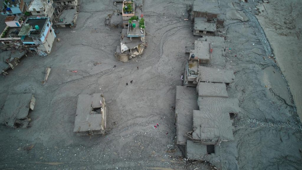
He warned that climate change is accelerating glacial melt, expanding high-risk glacial lakes and increasing the frequency of extreme weather events across the Himalayas. Stressing the need for stronger early-warning systems and regional cooperation, he called for real-time information-sharing between neighbouring countries to improve preparedness and reduce disaster risks. Edited excerpts: What exactly happened in Nepal, and why did it become so destructive downstream? Based on assessments by scientists across the world, this was clearly a rock-ice avalanche. A rock face failed and collapsed, bringing glacier ice down with it. What remains uncertain is the precise trigger. We do not yet know whether glacier retreat and melting destabilised the slope or whether the geological failure happened first and then affected the glacier. The bigger mystery concerns the volume of water involved. Yet satellite imagery has not identified a large pre-existing glacial lake in the area. One possibility is that the landslide temporarily dammed a river upstream, creating a landslide lake that later burst. Even so, scientists are still trying to understand where all the water came from and how the flood reached such extraordinary speeds. The terrain also played a role. The avalanche fell nearly a kilometre vertically before racing down steep slopes. The combination of gravity, water and debris allowed the flood to travel extremely rapidly downstream. How was this different from a conventional glacial lake outburst flood (GLOF)? A conventional GLOF occurs when meltwater accumulates in front of a retreating glacier, forming a lake that is often held back by fragile moraine material rather than solid rock. As glaciers shrink, these lakes can grow larger and become increasingly unstable. Such lakes can fail for several reasons: the moraine dam may collapse, a landslide may fall into the lake and trigger overtopping, extreme rainfall may cause it to overflow, or a rock or ice avalanche may strike it. In Nepal’s case, the event appears to have involved a significant geohazard component, namely a rock-ice avalanche. The key question remains why the rock face failed. Are such disasters becoming more common in the Himalayas? Nonetheless, the science, engineering knowledge and funding mechanisms already exist. What is needed is greater focus and commitment. How much of a role is climate change playing in these risks? Climate change is a major factor. Rising temperatures are accelerating glacier melt, creating larger glacial lakes and increasing the likelihood of destabilisation. But the impacts extend beyond glaciers. Higher temperatures are also affecting forests. In parts of the Himalayas, reduced winter rainfall leaves pine forests drier and more vulnerable to wildfire. At the same time, a warmer atmosphere can hold more moisture, which contributes to more intense rainfall events. Such events can trigger floods, landslides and other cascading hazards. These shifts in rainfall intensity, duration and frequency are among the most significant climate-related changes affecting the region.
In an interview, Mr Rizvi said a rock-ice avalanche clearly triggered the recent devastating floods in Nepal , though the sheer volume of water involved remains a subject of scientific investigation.
Preliminary satellite-based interferometric studies suggest the slope was moving more rapidly than usual in the days before the collapse, but the precise trigger is still being investigated.
The purpose of the list was not to create alarm but to prioritise action. States were encouraged to study the most critical lakes, install monitoring systems and prepare risk-reduction plans. These efforts are ongoing, but they need to be scaled up significantly. Can early-warning systems actually prevent disasters? They can significantly reduce loss of life. Switzerland provides a useful example. Scientists monitoring a hazardous rock face observed accelerated movement through satellite interferometry and other monitoring systems. That information allowed authorities to evacuate communities before collapse occurred. The science is available, and the technology exists. The challenge is implementation at scale. In the Himalayas, the terrain is vast and complex. Monitoring every high-risk slope, glacier and lake requires resources, institutional coordination and sustained investment. What mitigation measures are available for high-risk glacial lakes? There are three broad approaches. One involves syphoning water from lakes to reduce pressure on moraine dams. Another uses pumps to lower water levels. A third creates alternative drainage channels that safely release excess water. Do Himalayan countries share enough data on emerging risks? Not yet. Real-time risk reduction requires real-time information sharing. hazard monitoring should become more decentralised and operational While governments often treat such exchanges as diplomatic matters. If monitoring centres in India, Nepal, Bhutan and China could exchange information continuously, even simple observations could make a difference. For example, a sudden reduction in river flow or detection of unusual seismic activity could be communicated immediately, giving downstream communities precious additional minutes to respond. Most of the necessary infrastructure already exists. The challenge is administrative rather than technological. Given the fragile Himalayan environment, are governments building too much infrastructure? Mountain communities cannot be left without roads, telecommunications, bridges or power. The question is not whether infrastructure should be built, but whether it is built in a resilient manner. However, climate risks are changing. Infrastructure that was designed for a certain level of hazard may need to be reassessed as extreme events become more frequent or intense. The answer is resilient development, not abandonment of development. What is the biggest lesson from recent Himalayan disasters?
Every project should therefore be evaluated on a case-by-case basis, considering local geology, hydrology and seismic conditions. Large infrastructure projects today generally incorporate substantial engineering safeguards, and many have performed well under extreme conditions.
The challenge is that these lakes are often located at elevations of around 5,000 metres, where work is possible only for a few months each year and requires specialised equipment. India has identified 195 high-risk glacial lakes. Researchers reviewed decades of studies on thousands of glacial lakes and identified 195 that had repeatedly been assessed as potentially dangerous.
Climate change is accelerating glacier melt, which means many glacial lakes are growing in size. The Himalayas are inherently a high-risk mountain system. As these lakes expand, the associated risks increase. However, growing risk does not mean disaster is inevitable. River valleys containing high-risk lakes should have early-warning systems, evacuation plans and risk-reduction measures. In some cases, engineering interventions such as syphoning or pumping water can reduce lake levels. This was one of the reasons why India developed national programmes for GLOF risk reduction and landslide risk mitigation. The objective was to identify the highest-risk locations and systematically reduce risk before disasters occur. That may suggest a landslide lake was forming upstream. Mountain communities are often highly observant and can recognise abnormal changes in river behaviour. However, while a sudden drop in river flow might indicate danger, it does not tell people how large the resulting flood will be. That is where technology becomes important. Satellite monitoring, sensors and warning systems can complement local knowledge and provide crucial information on hazards that communities cannot directly observe. The goal should be to establish satellite-based and ground-based early-warning systems in every high-risk valley. Governments have a role, but hydropower companies, private-sector actors and non-profit organisations should also contribute. What does that classification mean? The list emerged after extensive consultations among scientific institutions, State governments and disaster-management agencies. A lake could be classified as high risk for several reasons: rapid growth, unstable moraine dams, lack of a safe outlet, or the presence of steep snow- and rock-covered slopes above the lake that could trigger overtopping. The lesson is that these are no longer isolated incidents. Events such as Kedarnath, Chamoli, South Lhonak and now Nepal show that the Himalayas are facing increasingly complex and potentially high-impact hazards. Governments have learned important lessons, and policies are evolving. But the scale of the challenge requires a much stronger response. Risk reduction must become a national mission, supported by scientific monitoring, resilient infrastructure, community preparedness and regional cooperation. The risks cannot be eliminated entirely, but they can be substantially reduced. In the context of a warming climate and rapidly changing mountain environment, that should be the priority. (With inputs from Kunal Shankar)
Q: Could warning signs have been detected before the Nepal flood? There are indications that residents observed reduced water flow in the river hours before the disaster.
