
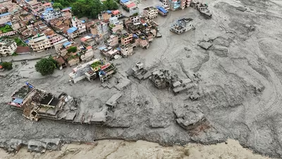
The flash floods that tore through Nepal’s Rasuwa district in the early hours of August 26, killing at least 100 but with hundreds and potentially thousands more missing on both sides of the Nepal- Tibet border, are among the deadliest in recent memory. The precise mechanism is still being investigated , but a picture is beginning to emerge — and one early assumption has already been overturned. Track Nepal floods live updates here
This was a fluvial flood — caused by rivers overflowing — and more than one likely interconnected river was involved. The hydrological signature is clear from Nepal’s own gauge data. The flood was not caused by extreme rainfall. Establishing this with complete confidence would require a gauge at the exact site of any cloudburst, since such events can be too localised for modelled precipitation to capture. But neither global weather models nor anecdotal accounts point to any extreme rain preceding the event.
At Furke Khola on the Trishuli, the water level jumped from 3.35 metres at 11.10am to 10.48 metres at 11.40am — a seven-metre spike in half an hour. Twenty-nine kilometres downstream (as the crow flies) at Kali Khola, the level rose more gradually, from 6.74 metres at 1.10pm to 12.35 metres at 2.20pm.
With rainfall largely ruled out, two hypotheses have been in play. Nepal’s Department of Hydrology and Meteorology, in an interim assessment relayed by the India Meteorological Department , suspected a Glacial Lake Outburst Flood (GLOF) — a flood caused when a moraine damming a glacial lake gives way. Nepalese officials cited by Reuters later suspected something mechanically different: the collapse of a glacier snout onto the valley floor hundreds of metres below. Before-and-after satellite images show lush green mountainside now buried under brown debris and sediment.
