
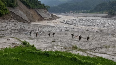
A devastating flash flood along the Tibet-Nepal border that has killed over 1,300 people has brought fresh attention to the growing environmental and geological risks in the Himalayan region, with Chinese experts linking the disaster to rising temperatures, retreating glaciers and increasingly volatile weather patterns.
Nie Yong, a researcher at the Institute of Mountain Hazards and Environment of China, said there are now more than 14,000 glacial lakes on the Qinghai-Tibet Plateau, covering a combined area of more than 1,100 square kilometres, with many continuing to expand. Chinese researchers say climate change is emerging as a central driver behind the growing frequency and severity of such disasters across high-altitude border regions.
The August 26 disaster was likely caused by a combination of factors, including rising temperatures and accelerated glacier melt, glacier retreat, local geological and geomorphological conditions and broader climatic influences, according to Chinese climate experts cited by news agency PTI . The August 26 disaster, and its links to climate change and glacier retreat, have now added another layer to the risks facing the region.
“According to our monitoring, we can see the short-time rain days, or the imbalance of the rain pattern and the rising of the temperature in Tibet,” said Sun Xiaoguang, head of the Meteorological Observatory of the Tibet Autonomous Region. Sun said the Tibet region may be affected by the climate change crisis, the report added. “As far as I know, and according to the reports published by the Meteorological Observatory of China, I think there are… there will be more and more extreme weather, or extreme weather incidents in China that are impacted by or affected by climate change,” he said, talking to PTI .
The primary concern surrounding the project had earlier been earthquake risks, given Tibet’s location along the collision zone of the Indian and Eurasian tectonic plates.
