
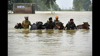
Repeatedly battered by monsoon floods that have claimed lives and caused thousands of crores in damage, Punjab is still without scientifically demarcated floodplains, with the state now telling the National Green Tribunal that the long-delayed exercise will be completed only by the end of September.
Event Context
However, in an affidavit filed before the NGT on July 27, it has sought another month, meaning another monsoon season will pass before Punjab has scientifically identified flood-prone areas along the Sutlej, Beas and Ravi rivers, delaying disaster preparedness and flood-risk mitigation.
The delay comes despite repeated floods exposing Punjab’s vulnerability.
Just last year, in August-September, exceptionally heavy monsoon rainfall triggered widespread flooding, the worst in nearly four decades, after embankments were breached and rivers overflowed, inundating thousands of acres of farmland and hundreds of villages.
Once the complete ORI and DEM datasets are received, the department will appoint a specialised agency to undertake Hydrologic Engineering Centre’s River Analysis System (HEC-RAS) modelling, which will form the basis for preparing the final floodplain zoning maps. Officials said the tendering process for selecting the expert agency will begin before the Survey of India submitted the remaining data to minimise further delays.
Team Analysis
The floods claimed lives, displaced thousands of residents, damaged roads and bridges, and caused extensive losses to agriculture, and personal and public infrastructure, estimated at nearly ₹13,000 crore, underscoring the urgency of completing scientific floodplain mapping.
Floodplain demarcation involves the use of high-resolution satellite and drone imagery, digital terrain data and advanced computer-based hydraulic models to identify areas that are likely to be inundated during a flood event.
The exercise is considered essential for regulating construction, protecting river ecosystems and improving flood preparedness.
The matter is being heard in an original application filed by Karnvir Thamman, a social activist from Banur, Mohali. During the previous hearing on April 15, 2026, the NGT had pulled up the Punjab government for failing to provide either the progress achieved or a firm timeline for completion.
The department said the mapped area had been revised after excluding locations outside the prescribed survey grid, as well as areas near the international border and other strategically sensitive installations.
Match Outlook
In October last year, the state had assured the green tribunal that the scientific survey will be completed within 10 months — August 2026.
In its affidavit, filed by Krishan Kumar, principal secretary, water resources department, the government said it had engaged the Survey of India to prepare high-resolution Ortho Rectified Imagery (ORI) and Digital Elevation Models (DEM), the foundational datasets required for scientifically delineating floodplain boundaries based on the highest flood level expected once in 100 years.
The state attributed the delay primarily to the late receipt of flight clearances from army authorities for drone operations in border areas. It informed the tribunal that the Survey of India had already supplied a substantial portion of the required ORI data and was expected to deliver the remaining datasets by the fourth week of September.
source
According to the status report, work in the Nangal region has progressed significantly. Drone surveys have been completed across the entire 1,292.90 square kilometre (sq km) project area, while data processing and ORI generation have been completed for 901.32 sq km. Digital Terrain Model (DTM) preparation has also been completed for 753.27 sq km.
In the Harike region, drone surveys have been completed over 422.84 sq km of the total 475.42 sq km project area. Data processing and ORI generation have each been completed for 162 sq km, while DTM preparation is currently in progress.
